
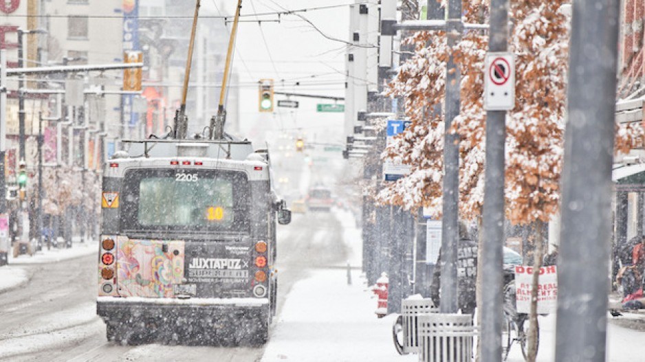
Heavy snowfall in Metro Vancouver and southwestern British Columbia has shuttered schools, caused transportation havoc and triggered power outages across the region.
It's part of a blast of winter that has also disrupted flights and workplaces across Canada, as multiple warnings of heavy snowfall and extreme cold blanket parts of the country.
All public schools in Metro Vancouver and the Fraser Valley were closed Wednesday, while some universities and colleges in the Lower Mainland, including the University of B.C., Simon Fraser University and the B.C. Institute of Technology, also cancelled in-person classes.
BC Hydro said thousands of customers in the southwestern corner of the province were without power due to the snowstorm, with the most-affected areas in the Gulf Islands of Salt Spring, Saturna and Galiano.
More than 30 flights were cancelled Wednesday morning at Vancouver International Airport, and officials were telling passengers to check their flight's status before going to the terminal.
Vancouver Mayor Ken Sim said an extreme weather alert was in place until Thursday, with extra shelter spaces opened at 15 warming centres across the city.
Teacher Cameron Wolber, who was playing in the snow with his daughter at a park in South Vancouver, said he was grateful that there was plenty of warning about the “huge dump of snow."
“Knowing it was coming was really helpful … it's great that all the school districts closed and I think it makes the roads a lot safer,” said Wolber.
Environment Canada said up to 20 centimetres was expected by this evening, and a snowfall warning was in place for all of Metro Vancouver, Victoria, Whistler and the Sunshine Coast.
Dozens of snowfall warnings also cover the southern portion of B.C. from the Chilcotin to Creston.
Those warnings carry on into the southwest corner of Alberta, where accumulations of heavy snow from Banff to Milk River could reach 35 centimetres before it tapers off Thursday.
DriveBC said it had issued travel advisories for almost all major routes in Metro Vancouver and the Fraser Valley, as well as some highways in the B.C. Interior, while transit operator TransLink warned riders to expect bus and SkyTraindelays.
“Drivers are advised to stay off the roads unless their vehicle is properly equipped with winter tires,” the DriveBC alerts said.
In the southern Interior, Highway 1 west of Revelstoke was closed in both directions Wednesday morning as crews conducted avalanche control work above the route.
Environment Canada issued warnings for several major highways in the province, including the Malahat on Vancouver Island, the Sea to Sky from Squamish to Whistler, the Coquihalla, the 97C Okanagan Connector, Highway 3 both from Hope to Princeton and from Grand Forks to Creston, and Highway 1 from Sicamous to Golden.
A series of weather systems also brought extreme cold to northern Alberta and central Ontario, blowing snow advisories in Quebec and snow squalls and rainfall warnings in separate parts of Newfoundland and Labrador.
Northern Alberta remained under an extreme cold warning and temperatures could dip to -40 C through the rest of the week.
On Canada’s East Coast, a messy weather system coated the streets of St. John’s, N.L., with dark, heavy slush as the city was pelted by snow and then by rain.
Schools were closed for at least part of the day across much of Newfoundland as Environment Canada called for high winds and snow squalls in the western part of the island, and a mix of snow and rain in the east.
The agency issued snow squall watches for western and eastern Newfoundland on Wednesday. Parts of the island’s Avalon and Burin Peninsulas were also under rainfall warnings calling for up to 40 millimetres of precipitation.
David Neil, a warning preparedness meteorologist with the federal weather agency, said much of that sloppy wet snow could then freeze over as temperatures dropped Wednesday night.
“It’s not a lot of fun,” Neil said.
Wind speeds hit 150 kilometres an hour on Wednesday morning in an area of western Newfoundland known as Wreckhouse, which is notorious for winds strong enough to knock over transport trucks, Neil added.
The same storm was responsible for the “very messy mix of precipitation” soaking Newfoundland was set to dump up to 50 centimetres of snow on the northern coast of Labrador by Friday evening, Neil said.
Extreme cold was also forecast for southern Ontario with icy conditions expected from Windsor to north of Toronto, as wind chill values fall to -30 C.
Toronto's Pearson Airport said Wednesday that passengers were still "flowing smoothly," with 437 planned departures and 450 scheduled arrivals, despite a "frosty day" with a wind chill bringing the temperature down to -20 C.
The airport said some flights from Germany are cancelled due to weather in Europe.
This report by The Canadian Press was first published Jan. 17, 2024.
Darryl Greer, The Canadian Press


